


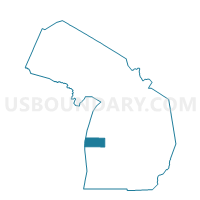
Voting Districts not defined, Oceana County, Michigan
About
Outline

Summary
| Unique Area Identifier | 599091 |
| Name | Voting Districts not defined |
| County | Oceana County |
| State | Michigan |
| Area (square miles) | 759.85 |
| Land Area (square miles) | 0.00 |
| Water Area (square miles) | 759.85 |
| % of Land Area | 0.00 |
| % of Water Area | 100.00 |
| Latitude of the Internal Point | 43.64725460 |
| Longtitude of the Internal Point | -86.80757510 |
Maps


Graphs
Select a template below for downloading or customizing gragh for Voting Districts not defined, Oceana County, Michigan


Neighbors
Neighoring Voting District (by Name) Neighboring Voting District on the Map
- Voting District 1057722000001, Mason County, MI
- Voting District 1218698000001, Muskegon County, MI
- Voting District 1270730000001, Oceana County, MI
- Voting District 1271620000001, Oceana County, MI
- Voting District 1273278000001, Oceana County, MI
- Voting District 1276356000001, Oceana County, MI
- Adell - V 9999 Voting District, Sheboygan County, WI
- BELGIUM - T 9999 Voting District, Ozaukee County, WI
- Voting Districts not defined, Muskegon County, MI
- Voting Districts not defined, Mason County, MI
Top 10 Neighboring County Subdivision (by Population) Neighboring County Subdivision on the Map
- Golden township, Oceana County, MI (1,742)
- Pentwater township, Oceana County, MI (1,515)
- Benona township, Oceana County, MI (1,437)
- White River township, Muskegon County, MI (1,335)
- Summit township, Mason County, MI (924)
- Claybanks township, Oceana County, MI (777)
- County subdivisions not defined, Oceana County, MI (0)
- County subdivisions not defined, Mason County, MI (0)
- County subdivisions not defined, Ozaukee County, WI (0)
- County subdivisions not defined, Sheboygan County, WI (0)
Top 10 Neighboring Place (by Population) Neighboring Place on the Map
Top 10 Neighboring Unified School District (by Population) Neighboring Unified School District on the Map
- Ludington Area School District, MI (15,954)
- Montague Area Public Schools, MI (8,442)
- Shelby Public Schools, MI (8,188)
- Hart Public School District, MI (7,899)
- Mason County Central Schools, MI (7,804)
- Pentwater Public School District, MI (2,262)
- School District Not Defined (Water), MI (243)
- School District Not Defined (Water), WI (0)
Top 10 Neighboring State Legislative District Lower Chamber (by Population) Neighboring State Legislative District Lower Chamber on the Map
- State House District 101, MI (92,671)
- State House District 91, MI (90,216)
- State House District 100, MI (86,569)
- Assembly District 59, WI (58,836)
- Assembly District 60, WI (57,434)
Top 10 Neighboring State Legislative District Upper Chamber (by Population) Neighboring State Legislative District Upper Chamber on the Map
Top 10 Neighboring 111th Congressional District (by Population) Neighboring 111th Congressional District on the Map
Top 10 Neighboring Census Tract (by Population) Neighboring Census Tract on the Map
- Census Tract 9508, Mason County, MI (2,748)
- Census Tract 108, Oceana County, MI (2,725)
- Census Tract 109, Oceana County, MI (2,214)
- Census Tract 39, Muskegon County, MI (1,915)
- Census Tract 110, Oceana County, MI (1,742)
- Census Tract 9900, Sheboygan County, WI (0)
- Census Tract 9900, Ozaukee County, WI (0)
- Census Tract 9900, Muskegon County, MI (0)
- Census Tract 9900, Mason County, MI (0)
- Census Tract 9900, Oceana County, MI (0)
Top 10 Neighboring 5-Digit ZIP Code Tabulation Area (by Population) Neighboring 5-Digit ZIP Code Tabulation Area on the Map
- 49431, MI (16,875)
- 49437, MI (6,902)
- 49455, MI (5,034)
- 49449, MI (2,675)
- 49446, MI (2,321)
- 49436, MI (1,622)